Lake Vermilion Area Weekend Weather – January 10-12
From the National Weather Service
——————————
KEY MESSAGES
– Light snow showers and/or flurries will be diminishing this afternoon and evening.
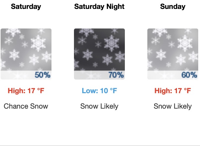
– A Clipper system arriving on Saturday and continuing into Sunday is likely to bring a widespread 2-4 inches of snow.
– Higher snowfall amounts of 4 to 7 inches are expected in Lake and Cook Counties due to terrain and lake influence. A Winter Weather Advisory is in effect for Lake and Cook Counties starting tomorrow.
– Much cooler temps are expected early next week with morning\ wind chills dropping to the negative teens to negative 20s.
Issued at 324 PM CST Fri Jan 10 2025
Light flurries and snow showers were observed earlier today, as a
secondary cold front propagates through the CWA along with a
shortwave trough aloft. Expect these flurries and light snow showers
to diminish this afternoon and evening as a brief period of ridging
aloft occurs. Model soundings show a descending layer of dry air
moving through the profile this evening through tonight, inhibiting
precipitation development.
This lull in precipitation will be brief though as a second
shortwave trough will propagate a Clipper system into the CWA on
Saturday, bringing a chance for accumulating snow. Precip onset is
expected to begin on Saturday morning in the far western CWA, with
snowfall expanding from west to east across the area through the
afternoon. Light to moderate snowfall will continue through Saturday
night before gradually tapering off from west to east on Sunday for
most locations.
Despite snowfall starting in less than 24 hours from now, there is
still a fair amount of uncertainty regarding total snow
accumulations on Saturday through Sunday. Starting with the
widespread view across the CWA, this Clipper will be bringing
relatively light snowfall in the 2 to 3 inch range for most
locations over a timeframe from Saturday morning through Sunday
evening. Confidence in a widespread 2+ inches of snow over 48 hours
this weekend is 70%. The uncertainty comes from the exact track that
this Clipper will take through the CWA and the resultant impact on
lake effect and terrain-enhanced snow.
Comparing the last few runs of both CAMs and global models, snow
amounts have been varying within a spread of a couple inches.
However, since there was an overall increasing trend in the 12z
suite of models, snow amounts were increased slightly in the
forecast update this afternoon. This puts a band of accumulating
snow of 3-4″ from north-central MN into the Arrowhead and along the
South Shore of Lake Superior. Since this 3 to 4 inches of snow will
be falling over a prolonged 48 hour period, decided against issuing
a Winter Weather Advisory at this time for much of the CWA. The
exception is in Lake and Cook Counties, where confidence in at least
3 inches of snow is higher.
While much of the snowfall associated with this weekend`s system
will be fairly light, higher accumulations are very likely to occur
around the higher terrain near the North Shore in Lake and Cook
Counties. South to southeast winds on Saturday afternoon through
Saturday night preceding the center of the low pressure will provide
a favorable amount of fetch needed to generate lake enhanced snow.
Delta-T between the lake sfc and 850mb will be fairly marginal
around 13 to 14 degC. However, this amount of instability will help
locally enhance snowfall, especially as model soundings show
sufficient saturation in the DGZ above the boundary layer. In
addition to lake enhancement, the southeast winds are expected to
provide orographic enhancement, especially in southern Cook County.
Given all of these factors, snow amounts of 4 to 7 inches are
forecast in Lake and Cook Counties with locally higher amounts
around 7-8 inches in the higher terrain between Grand Marais and
Grand Portage.
As the Clipper system this weekend propagates to the northeast into
Lake Superior on Sunday evening, it is expected to merge with
another low pressure system aloft moving south into the CWA from
northern Ontario. This merger of the two systems will keep light
snow in the forecast for the Arrowhead and South Shore into Monday.
Expect much cooler temperatures early next week as Arctic air enters
the area, with wind chills on Monday and Tuesday mornings in the
negative teens and negative 20s. Warmer temps arrive mid to late
next week with additional chances for precip arriving late next
week.
AVIATION
Issued at 516 PM CST Fri Jan 10 2025
A blanket of MVFR ceilings across the Northland will linger
through tonight with on and off flurries throughout. Saturday
late morning into early afternoon, a second system will bring
light snow showers to the region, with MVFR ceilings and
MVFR/IFR visibilities. Winds will temporarily back to south and
southeasterly ahead of the system.
MARINE /FOR NEAR SHORE WATERS OF WESTERN LAKE SUPERIOR
Issued at 324 PM CST Fri Jan 10 2025
Light snow showers or flurries are expected to end over western Lake
Superior this afternoon as drier air moves into the area. Winds and
waves will be quiet this afternoon into tonight as a brief period of
high pressure aloft develops. Relatively quiet conditions continue
on Saturday into Sunday morning, even as a Clipper system moves in
bringing light to moderate snow showers. Strong northwesterly winds
are expected to develop late Sunday afternoon into the evening as
the Clipper system moves east of the area and a tighter pressure
gradient force develops. Small Craft Advisories will likely be
needed with no gales expected at this time.
For the open water discussion, refer to the NWS Marquette Area
Forecast Discussion at weather.gov/mqt.
