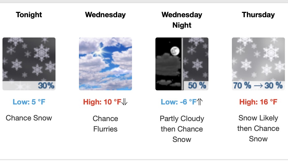
Lake Vermilion Area Weather – December 17-19
KEY MESSAGES
– Flurries and light snow are expected across the Northland this evening and overnight, transitioning into a short period
of lake effect snow along the South Shore through Wednesday.
-A clipper system brings accumulating snow Thursday with a widespread 3 inches or more possible. along and south of
Highway 2 and along portions of the North Shore. Snow will impact the Thursday morning commute and may affect the evening
commute.
– Quiet and cooler weather to end the week, with another warm up looking likely for next week.
DISCUSSION
Issued at 212 PM CST Tue Dec 17 2024
TODAY THROUGH WEDNESDAY: Some areas of flurries continue this
afternoon and evening under widespread overcast skies.
Temperatures will continue to fall through the day Wednesday,
getting into the low teens and single digits by Wednesday
afternoon. A weak disturbance crossing southern MN and WI this
evening and overnight should throw up a little moisture
advection our way and meet up with some vorticity advection
allowing for light snow development across the Northland.
Accumulations should be less than an inch, but folks may wake up
to a fresh dusting to a couple tenths of an inch. Gusty
northwest winds are expected along the North Shore overnight
into Wednesday morning, with some gusts approaching 40mph.
With cold air infiltrating and northwesterly flow, expect the
Lake Effect Machine to start up through the day Wednesday,
delivering some more light accumulations to portions of the
South Shore. Expect a half to one inch over northern Bayfield
County and up to 3-4 inches in northern Iron County.
THURSDAY: A stout clipper system dives down from the Canadian
Rockies Wednesday overnight into Thursday, nosing into north-
central MN around or just after midnight and overspreading the
region through mid morning. The heaviest snow is expected
through the day Thursday. Currently, the best chances (30 to
75%) for 2 to 4 inches or more is along and south of Highway 2
and along the North Shore from the Twin Ports through Lake
County. There is still lingering uncertainty with this system,
especially as hi-res model runs have started to extend into that
time range. While ensemble low placements are improving and
honing in on a track falling somewhere from central to southern
Minnesota, some of the latest CAMs have been coming in with a
more northern track, pushing the bullseye of the highest
accumulations back towards the Twin Ports and farther into
northern Minnesota. This track will also have a compounding
effect on the lake enhancement for the North Shore and Twin
Ports, which could mean a much higher local amount should that
hi-res solution pane out. Due to these lingering uncertainties,
have left NBM PoPs ride for now through this period, which seem
to be a happy medium. Deterministic models continue to show that
a good low level FGEN band should materialize to enhance a
synoptic band of snow wherever it does finally show up. While
much of the event should be a solid Winter Weather Advisory type
system, there is the potential that this FGEN band could
produce a localized band of near 6 inches.
FRIDAY INTO THE WEEKEND: Some ridging and high pressure pushes
in Friday, which could potentially bring some clearing skies and
tanking temperatures. Global models are wish-washy about the
potential for a little clipper to dive south Saturday, and
placement is still anywhere from North Dakota across Minnesota,
with some models having it fizzle out entirely before it gets to
us.
NEXT WEEK: Global models continue to pick up on the chance for
a weak cut off low to spin over the area Monday, which could
bring some additional light snow. Through next week, while
precipitation chances are unclear, there is a robust signal for
a well above normal temperature regime to move in, with high
temperatures reaching over freezing (a couple ensemble members
even suggest reaching 40F) on Christmas and through the next
weekend.
AVIATION
Issued at 525 PM CST Tue Dec 17 2024
Pretty status quo. Predominant MVFR ceilings persist through
the TAF period at all sites. Some flurries and light snow are
possible at times this TAF period with an area of light snow
expected to move up from the south affecting visibilities at
BRD, DLH, and HYR. Some flurry activity may be spurred by that
area of snow for HIB and INL, lasting into midday Wednesday.
Northwesterly winds continue.
MARINE /FOR NEAR SHORE WATERS OF WESTERN LAKE SUPERIOR
Issued at 307 PM CST Tue Dec 17 2024
Northwest winds continue through Wednesday. A period of strong
downslope northwest winds are possible along the North Shore
overnight tonight into Wednesday morning, from Silver Bay to Grand
Portage. We`ve issued a Small Craft Advisory through 10AM Wednesday
for these strong winds, and depending on trends, a Gale Warning may
be needed. Northwest winds should then weaken through the day
tomorrow, becoming easterly into Thursday morning. A quick round of
northeast winds are possible Thursday before becoming northwest
again into Friday morning. Wind gusts of 20 to 30 knots are
forecast from Thursday evening to late Friday morning. There is
a 30% chance of gales to 40 knot along the North Shore during
that time.
For the open water discussion, refer to the NWS Marquette Area
Forecast Discussion at weather.gov/mqt.
